SonarCharts™ are a special feature provided by Navionics, a manufacturer of electronic nautical charts. They are used in conjunction with sonar devices that create detailed images of the seabed underwater.
The functioning of SonarCharts™ is as follows: When a boat equipped with a sonar device travels over a body of water, the sonar device emits sound waves that are reflected off the seabed. The returning sound waves are captured by the sonar device and converted into data. This data contains information about the depths and structures of the seabed.
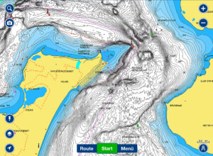
The collected sonar data is then sent to Navionics, where it is merged with data from other boats to create a high-resolution map of the seabed, offered under the name “SonarCharts.” These maps display detailed terrain formations, underwater structures, and depths, allowing boaters to precisely navigate the seabed. They help identify and avoid hazards such as shoals, wrecks, or submerged objects.
For anglers, SonarCharts™ hold special significance. With these detailed underwater maps, they can find the best fishing spots. They can specifically search for areas where fish are likely to be present, such as underwater hills, edges, or hiding spots. This increases their chances of successful fishing, as anglers know exactly where to cast their baits to have the best opportunities for a catch.
In summary, SonarCharts™ provide boaters with an accurate view of the seabed and help them navigate safely. For anglers, they are a valuable tool for finding the best fishing spots and maximizing their chances of success.