When discussing acquiring electronic charts for our boat, we first need to decide whether we want to use a plotter or a tablet/smartphone with a compatible app. Both devices utilize electronic nautical charts, often from the same manufacturer.
A plotter uses specialized memory cards that are inserted into the device to load the charts. For an app, the charts can be downloaded online, which has the advantage of always being up to date (as explained below). These apps are available for both Apple devices running the iOS operating system and Android devices. Typically, the apps are optimized for both tablets and smartphones. The advantage of the app is that you can easily update the charts online whenever there is new information. With a plotter, on the other hand, you may need to purchase new memory cards to get the updates.
In the following post, the advantages and disadvantages of both options are highlighted to provide personal decision-making assistance. Everyone can then decide which solution best suits their needs.

Plotter: A plotter is a standalone device specifically designed for navigation on water. It consists of a screen displaying electronic nautical charts and a control panel for interacting with the charts. A plotter uses GPS and other sensors to accurately determine the position of the vessel and display it on the chart. Plotters are available in various sizes and can be permanently installed in the helm of a ship.
Advantages of the Plotter:
- Robustness: Plotters are usually waterproof and shock-resistant, making them suitable for use in maritime environments.
- Display: Plotter screens are often still readable even in direct sunlight.
- Dedicated Hardware: A plotter has specialized buttons and controls optimized for navigation on water, providing easier operation.
Disadvantages of the Plotter:
- Cost: Plotters are generally much more expensive than navigation apps, especially high-quality models with advanced features.
- Limited Functionality: A plotter usually offers only navigation functions and cannot provide the versatility of a complete mobile platform.
- Mobility: Plotters are stationary devices installed onboard the ship and therefore cannot be used in a mobile manner.
(Excerpt from the manual)
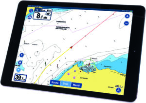
Navigation App: A navigation app is a software application that runs on a smartphone or tablet and simulates the functions of a plotter. The app utilizes the device’s integrated GPS to determine the position of the vessel and displays the charts on the screen. Navigation apps often offer additional features such as weather data, tide information, and route planning.
Advantages of the Navigation App:
- Cost: Navigation apps are usually more cost-effective or even free compared to dedicated plotters.
- Versatility: Since the app runs on a mobile device, it provides access to a wide range of features and services, including communication, weather forecasts, social media, etc.
- Multiple Devices: A Navionics Boating license can be installed and used on up to five mobile devices, either on iOS or Android, regardless of whether tablets or smartphones are used.
- Nautical Sensors: Navionics Boating also allows for the connection of external sensors, such as AIS, external GPS receivers, depth sounders, and wind instruments. Data exchange with some plotters is also possible.
- Mobility: By using a navigation app on a smartphone or tablet, it can be used on different vessels.
- Updates: Navigation apps can be regularly updated to receive new features, charts, and improvements.
Disadvantages of the Navigation App:
- Dependency on Hardware: Smartphones and tablets can be more susceptible to damage from water, shocks, or overheating.
- Readability: The screens of smartphones and tablets need to be shaded in direct sunlight for better readability.
- Battery Life: Navigation apps can increase the battery consumption of the mobile device, especially during prolonged navigation sessions, which may limit the usage time.